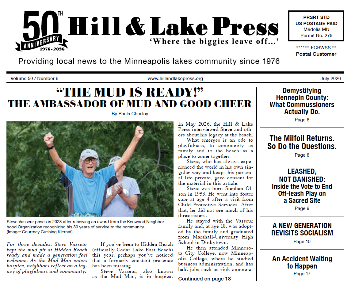
Public transit is nothing new to Minneapolis — in fact it was a critical component in the creation of Minneapolis as we know it today with transit corridors like Hennepin Avenue.
This three-part series will cover the history of public transit, its current state and what the future holds.
Public transit first reached Uptown in 1879 in the form of the steam-powered Minneapolis, Lyndale & Lake Calhoun Railway. From downtown it traveled Nicollet Avenue to 31st Street to Lake Calhoun, now named Bde Maka Ska, ending where St. Mary’s Greek Orthodox Church is today.
In 1887 a branch of the Lyndale Avenue horse-drawn streetcar line was built on 27th Street, ending at Irving Avenue. It didn’t last long. The 1880s saw inventors trying to harness electricity to power streetcars. The breakthrough came in 1888 in Richmond, Virginia, and the technology swept the nation. Beginning in late 1889, the Twin Cities converted their streetcars to electricity by 1891.
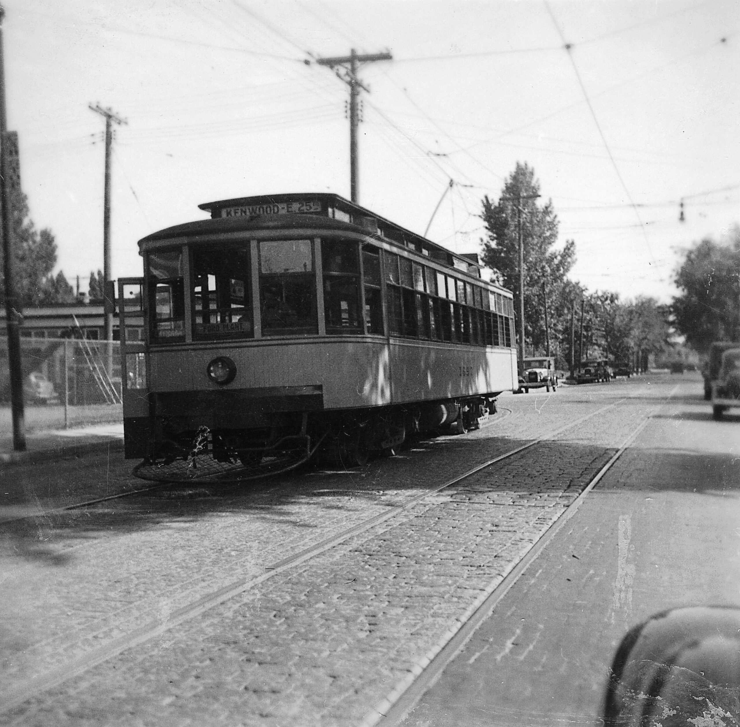
The first one to enter the neighborhood in 1890 was the Kenwood Line. From down- town it followed Hennepin Avenue to Doug- las Avenue to Oliver Avenue, ending at 21st and Penn next to Kenwood School.
The horsecar, a streetcar drawn by horses, on 27th Street was replaced in 1891 by the Lake Harriet line out Hennepin to 31st Street, then along the east side of Lake Calhoun, replacing the steam railway.
In 1898 the Lake Harriet line was combined end to end with the new Como Avenue line to form the Como-Harriet line, extending all the way from Lake Harriet to downtown St. Paul.
In 1905 track was built from Lake Harriet through Edina and Hopkins to Excelsior, with a separate branch to Deephaven. ComoHarriet service was extended to Hopkins. An entire new Lake Minnetonka service was added on top of the Como-Harriet.
1905 also saw the Lake Street line built across south Minneapolis from Hennepin Avenue to 31st Avenue S., then across the Mississippi River to downtown St. Paul, becoming the Selby-Lake line which continues to this day as a bus.
In 1892 an independent company opened a streetcar line between Uptown and St. Louis Park via Lagoon Avenue and Lake Street. It was absorbed into Twin City Rapid Transit (TCRT) in 1907 and through-service from St. Louis Park to downtown began, using Hennepin Avenue.
The Como-Harriet line grew a branch in 1913 on Xerxes Avenue from 44th to 50th Streets, designated the Oak-Harriet line. Another branch appeared in 1925 on France Avenue from 44th to 50th Street, extended again in 1929 to 54th Street.
Buses appeared after World War I, and TCRT got into the bus business in 1924, buying Twin City Motor Bus Company. The purchase included the Minneapolis-Glen Lake route that had been running on Hennepin and Excelsior Boulevard for a few years.
In 1932 it was extended to Excelsior, re placing the Lake Minnetonka streetcar line. The Deephaven streetcar line was replaced by the Deephaven Bus Company, using Minnetonka Boulevard, Lake Street and Hennepin to reach downtown.
The Nicollet-Hennepin bus, now Route 17, started in 1926. As it does today, it ran on Nicollet Avenue to 24th Street to Hennepin. At the time it didn’t go to St. Louis Park, instead terminating at Hennepin and 36th Street.
In 1938 the Kenwood and St. Louis Park streetcar lines were converted to bus and combined end-to-end to run through Kenwood. That continued until 1955, when they were again separated, and the St. Louis Park buses were rerouted through Uptown, becoming part of Route 17.
The Como-Harriet and Oak-Harriet lines were the last two streetcar lines to be replaced by buses in 1954, becoming today’s Route 6. In 1956 its branches on Xerxes and France Avenues were extended to the newly opened Southdale Shopping Center.
Public ownership
The transit system transitioned to public ownership when the Metropolitan Transit Commission (MTC) bought Twin City Rapid Transit in 1970. After decades of decline, public subsidies were available for the first time to rejuvenate and improve the system.
The bus fleet was replaced, introducing air conditioning for the first time. New bus garages were opened, dramatically improving vehicle reliability. Buses received radios and GPS, which tightened up on-time performance and let bus riders track their bus in real time. Bus shelters appeared.
Route 6 was extended to the developing areas beyond Southdale. MTC created an express on Hennepin to the University of Minnesota via I-94 (Route 114). Also new was the Route 2 Franklin Crosstown, providing an important connection that had never existed before.
Route 23 38th Street Crosstown was extended from 38th & Bryant to Uptown, another new connection. The Uptown Transit Center was built, creating a single transfer point for Routes 6, 17, 21, 23, 114 and 612. It was sited with a future Midtown Greenway light rail line in mind.
The only bad news during this expansion period involved the Kenwood bus line, now Route 25. Its ridership, always light, declined to minimal levels. It was downsized, first losing its off-peak service, then almost all of its rush hour as well. It’s down to a single round trip per weekday.
MTC eventually became part of the Metropolitan Council and was rebranded Metro Transit. Responding to all the improvements, ridership climbed year after year — then came Covid.
Downtown office employees were the heart of transit’s market, and that market has been cut in half. Afraid to venture out in crowds, many other riders went back to their cars. Initially Metro Transit cut service to match greatly reduced demand.
Then a labor shortage prevented them from ramping service levels back up. Route 6 is a case in point. Pre-Covid base service on Hennepin was every ten minutes all day, with five-minute rush hour frequencies.
Now it’s every 15 minutes all day, including the rush hours. Ridership is slowly returning, but will never reach pre-Covid levels, certainly not with 15-minute service.
Part Two of this series will discuss the future role of buses.