As we wrap up the third summer of the Green Line Extension light rail extension project, let’s take a moment to look back. I don’t mean reflect on the three years of construction, the work that is completed, the work that still needs to be done, the roads that are closed, or the increase in costs. I am asking that we look back a bit farther in order to recognize that there was once another major project in the same area of Minneapolis that was as sizable in its scope, time, and cost, as well as its inconvenience to the residents. As Dick Cavett used to say, “Time was…”
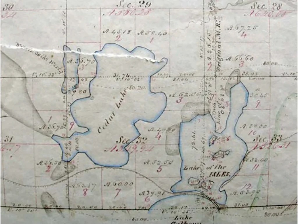
The 1880s. The Hill & Lake neighborhoods looked quite different. For starters, Brownie Lake, Cedar Lake, Bde Maka Ska (then called Calhoun), and Lake of the Isles (LOTI) were almost four separate lakes with the only connection being a narrow inlet between LOTI and Bde Maka Ska. Lowry Hill was called the Devil’s Backbone and had a north face described as a wooded bluff that was too steep to climb. Minneapolis was in its boom years. At the start of the 1880s, the city’s population was 46,887. Ten years later, the population was 164,738. The industries and businesses were growing and required that the city expand to accommodate the new workforce.
Real estate hawks like Thomas Lowry recognized that the area close to the downtown businesses was prime residential land. He created the Groveland Addition in 1872. The Lakeview (now called Mount Curve) Addition followed in 1885. Lowry used his own money to have Lowry Hill razed in 1886 to help with the growth. However, not everyone could afford the mansions in these additions. The middle class needed more modest pieces of land. It was time to convince the farmers to sell their land.
Many of the Lowry Hill and Lake of the Isles houses built between 1900 and 1920 can be traced to Denis Peters, Roswell P. Russell, and John Green who first owned the property in the 1850s. These men farmed the land and sold butter and produce in the nearby urban area. In 1880, John Green owned 56 un-platted acres between Franklin and Douglas Avenues. One interesting side note is that Nehemiah H. Emmans moved to Minneapolis in 1877 and entered the real estate business in 1898 when he married Luella Green, the daughter of John Green. (For you Monty Pythoners: “She’s got huge tracts of land.”) Emmans began selling off the Green’s Addition land plats. Emmans and Luelladivorced in 1904, and he married Jennie Mabie. Hmmmmm.
But even for successful opportunists, the cash cow dried up. This is where our real story begins. The desirable farm land had run out as the real estate developers ran into the swampy mess of LOTI. Where to build houses now? What could be done?
When Minneapolis established the Board of Park Commissioners (BPC) in 1883, the landscapes designer H.W.S. Cleveland recommended a citywide system of boulevards, parks, and parkways linking the Mississippi and Lakes Calhoun and Harriet as well as the small lake in Central (Loring) Park. Cleveland did not include LOTI because he realized what a challenge it would be. However, MBP decided to include LOTI and acquired it and its two islands.

In 1886, the first project to utilize the area began with the building of a road. The parkway around LOTI was completed in 1888. Wait. Well, it was completed as long as one didn’t need to use it when there was precipitation as it flooded and was impassable. So, in 1889, the first dredging project began on LOTI and lasted until 1893 which increased the shoreline. In 1892, the land between LOTI and Bde Maka Ska was purchased from the Joseph Dean estate to create the channel as well as Dean Parkway. In 1896, lights were added and then the walking paths in 1897.
In 1906, Theodore Wirth became the Superintendent of Parks and began a new series of projects: dredge the Chain of Lakes, build and rebuild shorelines, and construct channels to connect the lakes. In 1908, the second phase of dredging began on LOTI. The lake was dredged to an average depth of eight feet, and new shorelines were established. The work, completed in 1911, removed half a million cubic yards of fill from the lake and excavated the canal (now Kenilworth Lagoon) from LOTI west towards Cedar Lake. The project also raised the grade of the parkway from one foot above the water level to11 feet above the level of the lake. According to the BPC report, “After the dredging project was completed, the original 100- acre lake, which had consisted of 67 acres of swamp and 33 acres of dry land, was transformed into a 120-acre lake with no marshes and 80 acres of dry land.” And, about those houses…The lots facing Lake of the Isles that were previously undesirable had increased in value between 100 and 500 percent.
More residential lots were added in the Kenwood and Cedar Lake neighborhoods. The area was a thriving residential area close to downtown and the Hennepin Avenue shops. People loved the lakes and wanted them to be linked. The MPB supported this and continued the dredging projects and bridge building.
The linking of LOTI and Bde Maka Ska was commemorated with a large public celebration on July 5, 1911, called Linking of the Lakes Day. The celebration celebrated the waterways with aquatic sports and a pageant at night of illuminated boats. Theodore Wirth oversaw a “Wedding of the Lakes” ceremony, proclaiming, “What we have joined together let no man put asunder.”
But we’re not done yet. Let’s consider this an intermission as two more lakes still had to be linked.
Dredging of Cedar Lake and construction on the Kenilworth Lagoon and Channel had begun in 1911 on the south side of the lagoon and moved north with dredging soil used to raise the shoreline and some of the surrounding land to enable more development. In 1913, the canal between Lake of the Isles and Cedar Lake was opened with a water level drop of five feet in Cedar Lake to account for differences in water levels between the two lakes. Some dredging was delayed due to heavy storms. Two bridges over the canal and railroad were built.
Then, in July 1913, the park commissioners announced that it was a public necessity to have a canal between Cedar and Brownie Lakes. The MPB had acquired Brownie Lake and land for the Cedar Lake Parkway thanks to the donations of William McNair and his widow, Louise, (Brownie was the nickname of their daughter Agnes.) However, the BPC still needed to cross the railroad tracks. The condemnation proceedings began in November for a 100-foot-wide
right of way across railroad property owned by the Great Northern Railway. In 1914, the excavation of the canal under the Great Northern Railway Company’s tracks began and Cedar Lake Boulevard was completed.
Finally in 1917, the dredging and filling work at Cedar Lake was completed, the Minneapolis Park Board voted to pave the Grand Rounds, and a channel between Cedar Lake and Brownie Lake opened.
After 31 years, the four lakes were connected! The cost? Well, just to link LOTI and Bde Maka Ska, the cost was $125,000 which is over $3,000,000 today. The Linking of the Lakes project was lengthy, expensive, delayed by unforeseen issues, and required road closures and detours.
After reading all the steps involved in the Linking of the Lakes, do you feel any better about entering into year four of the light rail extension project?
Here’s an idea. Remember the Linking of the Lakes celebration in 1911? There were just two lakes linked, and to be a bit of a stickler, those two lakes were already linked. But it’s all in the optics. According to the Metropolitan Council webpage on the light rail project, “civil construction (structures and stations) is nearly 60% complete” including 11 of 16 stations, 25 of 29 bridges completed or underway, all eight tunnels completed, and 114 of 131 retaining walls completed or under construction.
That calls for a midway celebration. Let’s grab some railroad handcars, throw some streamers on them, and send them on parade!
Josie Owens lives in Lowry Hill.


